For the GPS geeks
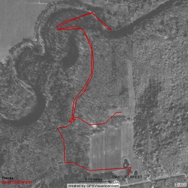
Here's something cool I came across recently: GPSVisualizer.com. It allows you to upload a GPS track log and plots it over various maps, satellite or aerial imagery. For example, I took the track I saved from Daktoberfest and put it over an aerial photo. This is the same thing that Jon did to generate the trail maps he distributes at the BBQ, but I didn't have to learn Photoshop.
There are even modes for creating Google Maps and Google Earth overlays. I haven't figured out yet how to save the Google Map it gives me.
I intend to use this tool for documenting our travels to, from and during the meet. I just thought I'd pass it along in case anyone else wants to try it.
posted by Jason @ 4:16 PM
3 comments
![]()
![]()

3 Comments:
Cool, I've bookmarked that one. I also have a couple of GPS tools I'll be playing with.
I'll be helping Beta test this utility. I haven't uploaded any data to the site yet but will be doing some preliminary testing this weekend. If it works like I'm hoping, it'll have real time tracking on a Google map.
I also set up a dash webcam in the truck. Still trying to work a few bugs out of that also. The biggest problem I'm having is I have to put the Cingular wireless card in the lower card slot because of the way my IEEE1394/USB2.0 card sticks out, which also prevents me from raising the antenna. I just ordered an external antenna to mount of the roof of the truck. Hopefully that should resolve the signal strength issues I'm running into.
Pretty amazing what you can do when you have Internet access in the vehicle like Walt. Should be cool.
Yea, I took a ride down to Taco Hell in Torrington last night but was having two problems. Like I said earlier, my biggest problem is the configuration of the laptop. It's an older T22 that only has 1 USB port on it and I have 3 USB devices to plug in. I have a PCMCIA firewire card (for my mini DV-Cam) that also gives me two additional USB 2.0 ports, but because of the shape of the part that sticks out, it blocks the upper slot if inserted in the lower one. I even went as far as getting a small self powered USB hub to run off the one USB port but it didn't have enough power to run all 3 USB devices at the same time. So I've been putting the firewire card in the upper slot and the Cingular card in the lower, but again, the firewire card gets in the way of the antenna. Not being able to raise the antenna seems to dramatically cut the signal strength of the cellular card. At least I hope that's the problem as I'm a bit concerned it might be causing some radio interference. I'll know for sure when the external antenna I ordered for it arrives. Hopefully, that will resolve the connectivity issues I've been having when running both cards. When running the cellular card by itself, I have a pretty reliable signal that's actually not all that bad as far as speed is concerned.
The other problem I was having was with the software itself. It seems like GPS applications still lean heavily towards standard serial GPS devices on a com port. A number of the applications I've tried so far didn't support a USB connected GPS. Which is stupid as most of your newer GPS units are USB and the newer laptops don't even have serial ports. I guess the software developers are still behind.
Post a Comment
<< Home